The Written Record — 1715 to 1900
A people who kept no writing must be read in other people’s handwriting. What follows is the documentary spine of the Waccamaw Indian People: the sightings, the war, the map, the long silence, the deed, and the century of paper that followed — set down in order, with the sources named, and with the gaps left open where they are.
Chief Hatcher put the problem plainly: “We are the only race in this country that must prove who we are.” This is the proving.
I. The people on the black water
The name is the river’s. “Actually the Waccamaw is the name of a river, not a people,” Chief Hatcher said. “We called it Blackwater. Waccamaw. So we became Blackwaters when the white people got here.”
The Waccamaw lived along that river, in a territory reaching from Lake Waccamaw in present-day North Carolina down to Winyah Bay near Georgetown, South Carolina — country that includes the whole of modern Horry County. They were one nation among many. The historian Chapman J. Milling, in Red Carolinians, places the Waccamaw within a loose confederacy of Siouan-speaking peoples: the Sewee, Santee, Congaree, Wateree, Sampa, Winyah, Waccamaw, Pee Dee, Sara (or Cheraw), Waxhaw, Sugaree, and Catawba. Their close kin and constant allies were the Pee Dee; the Winyah and Waccamus appear in the records as other names for the same or nearly the same people; and some reference works treat the Cape Fear as part of the Waccamaw.
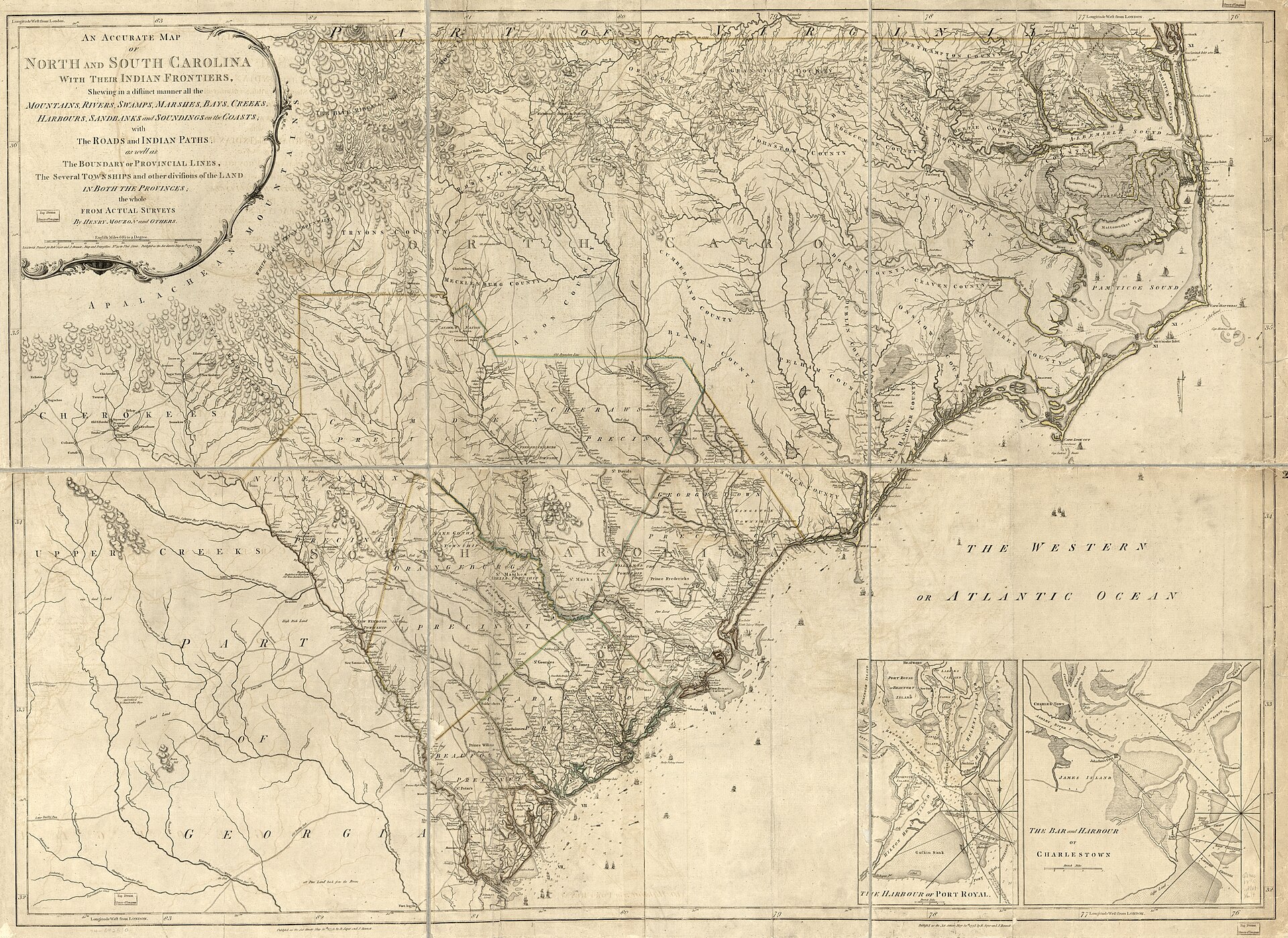
Henry Mouzon, “An Accurate Map of North and South Carolina With Their Indian Frontiers,” 1775. Library of Congress; public domain. The Waccamaw River runs from the North Carolina line to Winyah Bay — the length of the homeland.
II. 1715 — six hundred and ten people
The first hard number comes from the colony’s own count. A colonial Carolina census in 1715 recorded four Waccamaw villages with a total of 610 inhabitants, about 210 of them men — a figure now carried on the State historical marker at the tribal grounds. Independent researchers place the tribe’s population near 900 at the start of the previous century, before European disease. Other accounts describe six villages in the South Carolina area whose names were never written down.
Whatever the exact count, 1715 establishes the thing that matters: a decade before Herbert drew his map, the Waccamaw were a populous, multi-village nation that the colonial government counted.
III. 1716 — peace, out of fear of the Cherokee
The first dated moment after the count is a treaty. Red Carolinians (p. 150) records that on August 6, 1716, the “Waccamus” made peace with the settlers — and names the reason: they feared the Cherokee. It is a small entry, and it establishes something the later fight would turn on. In 1716 the Waccamaw were a political body, dealing with a colonial government, making a decision and keeping it.
IV. 1720 — the Waccamaw War
Four years later that relationship collapsed. There were trading posts along Winyah Bay and the Black River — the Wineau Factory, also called the Waccamaw trading post — where deerskins and corn were exchanged for knives, tools, liquor, arms and ammunition. The Waccamaw believed they were being cheated, and struck back at the traders.
The colony’s response was military. Red Carolinians (p. 203), citing the British Public Records Office (VIII, 70–71), lists the Waccamaw in 1720 among a confederacy of “very wild and savage people.” By the accounts that survive, about sixty Waccamaw men, women and children were killed or taken captive. Standard histories say the survivors scattered and joined the Catawba, and that the Waccamaw were effectively finished as a nation.
Chief Hatcher disputed that ending, and he had a document for it. King Hagler of the Catawba was summoned to Charleston and asked to bring the Waccamaw to heel — and answered that he could not:
“And Hagler says, ‘I can’t get them to mind me either.’ So the history book that said we joined the Catawbas probably is inaccurate.”
If the Catawba could not govern them, they had not been absorbed. Some went to the Catawba, some to the people later called Croatan, and — this is the tribe’s position — some simply stayed. A people who survived by not being governable.
V. 1725 — Herbert’s map
Five years after the war, an English official drew the single most important document in this record.
Colonel John Herbert, commissioner of Indian trade for the Wineau Factory on the Black River, produced a map of the province in 1725, marking the Native towns he knew. Among them, on the upland between the rivers, he set a Waccamaw village — north of the Little Pee Dee, some distance west of the Waccamaw River, and roughly north-northwest of present-day Conway.
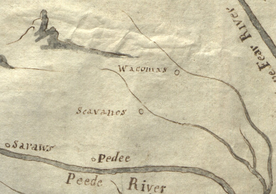
Detail from John Herbert, “New map of his majesty’s flourishing province of South Carolina,” 1725. Hargrett Rare Book and Manuscript Library, University of Georgia Libraries; public domain.
Two things make this map matter.
First, it is independent. Herbert’s map is not a tribal document. It is cited in the scholarship of the region’s other Native peoples — historians of the Lumbee read the same map as identifying enclaves of Cheraw, Pee Dee, Waccamaw and “Scavano” living on their traditional lands along the Pee Dee and its tributaries. The Waccamaw village on it is not a claim the tribe makes about itself. It is a colonial officer writing down what he saw.
Second, it is in the right place. The tribe’s own analysis holds that Herbert’s village sits at or very near the ground that became the Dimery Settlement — and that the chain of title over that ground shows no mass transfer of population, only conveyances within one white family until 1813.
VI. 1755 — the last mention, and then nothing
The Waccamaw appear by name one final time. In 1755, John Evans noted in his journal that Cherokee and Natchez raiders had killed some Pee Dees and Waccamaws “in the white people’s settlements.”
Then the record goes quiet for two generations.
The silence is not evidence of disappearance. It is evidence of a policy. As the researcher Forest Hazel observes, “It is very unusual to find Indians listed as such after about 1780 in any part of the South.” The Nottoway and Gingaskin of Virginia were counted as “free colored” in 1830 while still living on their own reservation land. The Meherrin, Chowan and Saponi of North Carolina were written down as “mulatto” or simply “colored.”
The instruction was explicit. Census rules before 1850 held that “Indians are to be counted for the purpose of gaining representatives for the states, but not to be counted as Indians.” Record keepers were told to write “Free Person of Color,” “Free Colored,” “Mulatto” — anything but Indian — in part for fear that the word Indian would invite land claims. The tribe has a name for this: documentary genocide. Chief Hatcher wrote it as “an attempt to exterminate us (and other Indians) through paperwork.”
So the people did not vanish in 1755. The word for them did.
VII. c. 1790s — the land is granted away
After the Revolution, South Carolina began granting land to settlers. A tract of roughly 1,000 acres — the ground the Waccamaw had lived and hunted on — was granted to Josiah Lewis. Under colonial and state law the people already living there held nothing: they had no deeds, because they had no courts in which to record them, and no concept that the earth could be owned.
They were removed. Chief Hatcher, writing for the tribal paper:
“The new owners demanded that the Indians leave their newly acquired land, but many of them refused. They could not understand why they could not live on the land where they were raised and where they raised their children. It wasn’t until local authorities authorized deadly force that many left their homes and hunting grounds.”
March 10, 1806 — Josiah Lewis conveys to William Lewis. The land stays in the family. No one from outside moves onto it.
VIII. December 10, 1813 — bought back
William Lewis sells 300 acres to a man named John Dimery. The deed survives; it is the tribe’s Exhibit 6, and it is the hinge of the whole history. Land that had been taken from Native people came back under Native title, by purchase, on the same ground.
“In 1813 a fella named John Dimery, which is kin to me … gathered together a bunch of his friends, collected some money, and they bought 300 acres of land back from Mr. Lewis. And that land is what became the Dimery Settlement.” — Chief Harold Hatcher, oral history, 2014
Before that deed, almost nothing is known of John Dimery. That is the honest statement, and the tribe’s own petition makes it: “Prior to the purchase of the before-mentioned 300 acres, little is known of John Dimery.” He enters history as a man buying land.
The fifty-eight years between Evans’s journal and John Dimery’s deed are the gap in this record, and no chain of names has been found to bridge them. The people who kept the memory kept no paper; the people who kept paper were forbidden the word. That is not a failure of the tribe’s history. It is the intended result of a policy, and it is why the federal standard asks for a reasonable likelihood rather than proof beyond doubt: the Department is required to “take into account historical situations and time periods for which evidence is demonstrably limited or not available.” This is precisely such a period. What the tribe argues — and what its petition argues in exactly these terms — is that the weight of the evidence points one way: the same people, on the same ground, before and after.
“Can the case be made that these Dimerys were the descendants of the old Waccamaw Village? This is very subjective and due the fact that the Indians kept no records, conclusive evidence will never be found. However, considering the facts as we know them, a preponderance of the evidence clearly demonstrates that they were.” — the tribe’s federal petition, Section 4
The historian Dr. John Ross reached the same place from outside: county records, he wrote, imply that the present-day Waccamaw descend from persons holding legal title by about 1800, and it is presumed some of those persons belonged to tribes present at contact — “primarily the historic Waccamaw and Cape Fear.”
IX. 1820–1900 — a community in the county’s handwriting
From the deed forward the record is continuous, and it is dense. It is also, almost entirely, a record of other people trying to decide what these people were.
1820. John Dimery appears on the Horry District census as a Free Person of Color, heading a household of three males and two females — seven years after buying his land. Note the category: South Carolina law held that a single drop of “Negro blood” required a person be listed as Negro. The Dimery Settlement people were not listed as Negro. They were not listed as Colored. They were listed as Free People of Color, and their community was set apart in the records as its own township.
1850. The settlement has grown to at least four families — John Dimery, Willis Thompkins, Cockran Thompkins, and Sara Cook — about 27 people. Oral tradition holds that John Dimery gave the land for Pisgah Church around this time, and that Dimerys are buried in a small cemetery near it.
1850. John’s son James “Jim” Dimery is in prison alongside a Mr. F. G. Burroughs; the account calls him a Croatan — the regional shorthand for a mixed-blood Indian, used by people who would not be called Colored and could not pass as White.
1863. James Dimery, John’s brother, born in South Carolina, is a Union soldier — captured by the Confederates around September 20 and sent to Kentucky for prisoner exchange on September 30. The record ends there. He was not enslaved; he had been listed as a Free Person of Color in 1850. Why a southerner fought for the North is not recorded, and the tribe does not pretend to know.
August 11, 1887. The Horry Herald announces that the “Dimery Church” will be pastored by Reverend J. W. Todd. By now the community includes Turners, Hatchers, Nichols, Hemingways, Coopers and Cooks. A separate church, in print, under the settlement’s own name.
June 1900. On Schedule 1 of the Twelfth Census of the United States — the “Indian Population” schedule — appear David Dimery, son of John, and Peter Hatcher, son of Isaac Hartley Hatcher, with their kin. The enumeration was taken in North Carolina; the birthplace given is South Carolina, Horry County. Most of those listed described themselves as Croatan.
That schedule is worth pausing on. In 1900 the Census Bureau removed the “mulatto” category entirely — for that one census the enumerator’s choices were White, Black, Chinese, Japanese, or Indian. In the one year the federal form offered an Indian box and no in-between box, named sons of the Settlement’s founding families are on the Indian schedule.
April 23, 1921. The Horry Herald, reporting a dispute between two settlement families: “They are mixed as to race, claiming that they have Indian blood in their veins.”
September 8, 1921. Furman Hughes is charged for marrying a Dimery girl “who does not belong to the White race.” He is fined $500 and sentenced to a year in jail. Marrying into the settlement was a crime.
September 5, 1923. John Brooks Dimery marries Aggie Hatcher, a distant cousin — the Dimery and Hatcher lines joining. On the affidavit he writes his race as White. The license is issued marking him Croatan. The state would not let them be White; it would not call them Indian; it invented a third word.
April 24, 1924. The Horry Herald, on two Black women in a lawsuit over a mule, notes they were “for long years the only true blue darkies in the whole of Dog Bluff Township.” Read it the other way around: by the county’s own reckoning, nearly everyone else at Dog Bluff was something else.
X. What outsiders have written
None of the above rests on the tribe’s word alone, and the outside record deserves to be shown whole — the parts that help and the parts that do not.
For. In 2024 the Horry County Historic Preservation Commission erected a State historical marker at the tribal grounds (Marker 26-34). Its text records the tribe’s territory “from Lake Waccamaw in N.C. to Winyah Bay,” the 1715 colonial census of “four Waccamaw villages with a total of 610 inhabitants,” the 2004 purchase of the grounds, state recognition in 2005, and — in the county’s own words — the tribe’s “historical ties to the Dimery Settlement (3 mi. S), a small community of Native families founded in the early 1800s in Dog Bluff Township,” which “included churches and a public school for Native children.” A government body put that on a sign beside the road.
Coastal Carolina University, the Horry County Museum and the tribe together produced Waccamaw Indian People: Past, Present, Future, a public-history and interpretive-trail project that won a Society for American Archaeology national award for outstanding public archaeology and an honorable mention from the National Council on Public History. Archaeological field research in the region has been led by Dr. Carolyn Dillian of CCU’s anthropology faculty.
One further caution belongs here. A 1987 listing of Waccamaw surnames compiled for the Lumbee petition does not include Dimery, Hatcher, Cook, Turner or Thompkins. That is what one would expect: it recorded the Waccamaw who went into the Lumbee after 1720, not the families who stayed on the river. The two lists describe two halves of the same scattering.
The researcher Forest Hazel was engaged in 1994, under a federal Administration for Native Americans grant, to study the Settlement; his article is published through the Horry County historical community. Dr. John Ross wrote that county records imply the present-day Waccamaw descend from persons holding title by about 1800, presumed to be of “the historic Waccamaw and Cape Fear.” Independent researchers documenting a Waccamaw group that left the Carolinas in the 1770s put the matter this way: some joined the Catawba and were absorbed — “Some did but not all.”
Against, and the answer to it. The Horry County Historic Resource Survey, prepared by New South Associates for the South Carolina Department of Archives and History and the county, states that after the 1720 war “the Waccamaws were essentially eradicated, though some survivors may have existed as late as 1733 and integrated with tribes further inland.” That is a state-commissioned document, and it says the tribe ended. It should be met squarely rather than ignored.
Three things answer it.
It is not a study of the Waccamaw. The survey is an inventory of buildings, made to judge structures for National Register eligibility. Its Native American content is two paragraphs of background scene-setting, drawn secondhand — and its citation for the eradication sentence is Milling, page 227, while the same historian at pages 150 and 203 supplies the 1716 peace and the 1720 confederacy. One book, three pages, two different stories. A passing summary in a building survey is not a finding about whether a people survived.
The eradication story was contested at the time by the person best placed to know. When the colony asked King Hagler of the Catawba to bring the Waccamaw to heel, he answered that he could not — which is difficult to square with a people who had been absorbed into his own nation. Independent researchers reviewing the same question in 2020 put it plainly: some joined the Catawba and were absorbed, “Some did but not all.”
And “essentially eradicated” is not the standard. Federal acknowledgment asks for a reasonable likelihood, and expressly “will not require conclusive proof.” Survival is demonstrated by what follows — the deed, the settlement, the church, the school, the 1900 Indian schedule — not disproven by a nineteenth-century assumption repeated in a twenty-first-century footnote.
The silence that proves the point. That same survey never mentions the Dimery Settlement. Not once. It catalogues houses, barns and tobacco barns along Dog Bluff Road, marks them all “Not Eligible,” and records no Native community there.
That is not evidence the Settlement was not there. It is evidence of what a survey of structures is built to see. A community is not a building; a church congregation and a schoolhouse full of children do not survive as architecture. The gap is real, and it is fixable — a determination of eligibility or a National Register nomination for the Settlement would put it into the state’s inventory where it belongs, and it is precisely the kind of work the tribe’s academic partners do.
It is also, in its way, the whole story of this exhibit. The erasure did not stop in 1850. It is still being written into official documents, by people who are not malicious, working from sources that were themselves compiled by people who had been instructed not to write the word Indian. Which is the point: a record assembled under a policy of erasure cannot be read as though it were neutral. The federal rule now says as much, requiring that periods of demonstrably unavailable evidence be taken into account. The absence of the word is the fingerprint of the policy, not proof of the absence of the people.
XI. What the record holds
Against four centuries of that, one small thing survives from inside the community — a memory, recorded in the tribe’s petition. One of the tribe’s oldest members recalled his mother saying that her grandmother said she was Indian. Asked what kind, she answered:
“a Wacca something”
That is the oral thread, and it is thin, and the tribe has never pretended otherwise. But it runs to the same place all the paper runs.
The record, whole:
| 1716 | Peace with the settlers, out of fear of the Cherokee |
| 1720 | The Waccamaw War; some 60 killed or captured; survivors scatter, some stay |
| 1725 | Herbert maps a Waccamaw village near what becomes Dog Bluff |
| 1755 | Evans’s journal — the last mention by name |
| 1755–1813 | The silence. Not absence: policy |
| c. 1790s | The land granted to Josiah Lewis; the people removed |
| 1813 | John Dimery buys back 300 acres |
| 1820 | John Dimery, Free Person of Color, Horry District |
| 1850 | Four families, 27 people; Pisgah Church |
| 1887 | The Dimery Church, in the newspaper |
| 1900 | David Dimery and Peter Hatcher on the federal Indian schedule |
| 1921–24 | The prosecutions, the licenses, the newspaper’s own arithmetic |
For most of the twentieth century, none of this was enough, because the federal standard asked the tribe to reach past 1755 and name a Waccamaw. In 2015 the Department of the Interior rewrote its rules and defined the word it had never defined: “Historical means before 1900.” The reach the tribe was asked to make now ends inside the century this exhibit documents.
The argument was never wrong. It was early.